Contents
Index
Point Properties
The Point Properties function will display the point Co-ordinates and code on the screen.
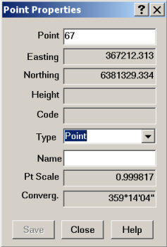
Point
This is the point number that the properties are being displayed for. You can click on a point on the screen, or enter the point number at the keyboard. Type in the point number and press ENTER or TAB to fetch and display the point Co-ordinates.
Easting
Every point must have an Easting (X) value; it is stored to more than 6 decimal places but only displayed to three decimal places. You can see the Easting (X) displayed in the bottom left of the screen as you move the mouse.
Northing
Every point must have an Northing (Y) value, it is stored to more than 6 decimal places but only displayed to three decimal places. You can see the Northing (Y) value displayed in the bottom left of the screen as you move the mouse.
Height
The height (Z) value for the point is optional. If a point has no height value, this field will be blank. Computed points like lot corners will generally not have a height value. The height value is stored to more than 6 decimal places but only displayed to three decimal places.
Code
The point code is a text string that is associated with the point. Generally this will be entered during the field survey to indicate what type of point feature is being measured. e.g. a code ‘FC01’ may be used to tag a point on a fence line (fence line 1). The code can consist of alpha and numeric characters, it can be of any length, but generally is less than 10 characters long. There is also a point Description in the Properties that can be used for a longer point description.
Type
This is the type of point. In Geocadastre, a point can either be a Point, or a Control Point, or a Reference Mark.
Name
A point can have a name. Eg. for a Control Point, the control point name can be entered.
Pt Scale
This is the scale factor of the grid at the point.
Convergence
This is the angle between true north and grid north at the point.